
Swimming holes in Washington
In the heat of summer, what better family activity is there than frolicking in a refreshingly cool and kid-friendly swimming hole? In their book “Swimming Holes of Washington: Perfect Places to Play,” authors Anna Katz and Shane Robinson list out prime natural swimming spots around Washington — from the Olympics to the Cascades — and provide all the details needed to head out for a family swim. In a special excerpt for ParentMap, the authors selected five fantastic swimming holes that will particularly appeal to kids and families. Now get splashing!
One note: Kids and water together call for very close attention to safety. Check out these water safety tips and stay safe on your swimming hole adventures!
First up: McCormick Park
Editor’s note: This excerpt was first published with permission in 2018, and was most recently updated on July 30, 2025, with a thorough fact-check. If these lovely swimming holes have whetted your family’s appetite for finding and playing in nature’s best kid-friendly swim spots around Washington, check out “Swimming Holes of Washington: Perfect Places to Play” for dozens more worth-the-trip, super-cool swimming spots for Northwest families.
1. Snoqualmie River: McCormick Park
This is a swimming hole for you loving parents and your lovely offspring. McCormick Park is a well-kept family spot, with easy access to all the amenities that make for a low-hassle day away that’s lots of fun. It’s definitely not somewhere you go to get away from it all, but it’s the perfect place for a picnic and a swim. In short, this spot is excellent for a day trip with a swim as the central activity — or a supplement to the range of goings-on in the region.
Kids love the park’s soft, sandy beach — there’s a healthy 30-degree slope to it, great for rolling downhill or running around, without caretakers having to worry about little ones tripping over a boulder or taking a spill on some treacherous rocks. And it’s wide open, too, providing a low-key view and ample sun all day long and then into the summertime evening. The water runs slow and cool; during the summer, the current is lazy, just right for relaxing on an inner tube under the big blue sky.
About 0.25 mile up from the main spot is Taylor Landing, which has a boat launch. This park isn’t quite as pretty, but it is a little more private and slightly less civilized. When the water is low enough, you can walk from one park to the other.
We’ve included McCormick Park not only because it’s a nice place to swim, but also because it’s close to the quaint, epitomously Pacific Northwesty logging town of Duvall and other outdoorsy activities. Close at hand, you’ll also find a dog park, a skate park and many kid-friendly restaurants. Nearby farms are dedicated to organic and sustainable agriculture, and Sno-Valley Tilth provides farm tours throughout the summer and early fall. The Snoqualmie Valley Regional Trail runs through McCormick Park, winding 31.5 miles past the Snoqualmie Valley’s lush farmlands from Carnation, Fall City and Snoqualmie to North Bend. All kinds of folks use this trail: horseback riders, hikers, mountain bikers, birders and good ol’ regular walkers — before or after a swim.
Getting there
From Redmond, east of I-405 via State Route 520, take Avondale Road Northeast to Northeast Novelty Hill Road and turn right onto it. After 0.7 mile, at a roundabout, take the second exit. After 4 miles, turn left onto West Snoqualmie Valley Road Northeast. After 0.3 mile, turn right onto Northeast 124th Street. After 1 mile, at a roundabout, take the third exit, onto SR 203/Carnation-Duvall Road Northeast. After 2.2 miles, turn left at unpaved Northeast Stephens Street and park in the lot.
Details
- Type: Lowland river, lazy current in summer, beach
- Location: Roadside in city park in Duvall east of Redmond via SR 520 and SR 203
- Water: Cool to warm, clearish, cleanish, blue-green
- Season: June through September
- Who’s here: Kid-friendly, dog-friendly; families barbecuing, kids playing, people visiting local farms, cyclists
- Amenities: Parking, restrooms, outdoor beach shower, picnic tables, grills; food nearby
- Local’s tip: For five weeks during the summer, McCormick Park hosts a free Wednesday concert series; come for the swim, stay for the music
- GPS coordinates: 47.7406 N, –121.9891 W
Next up: Big Eddy
2. Skykomish River: Big Eddy
Big Eddy is just a couple miles from the town of Gold Bar and directly off US Highway 2, so it’s easily accessible. This place is not a secret, nor a place for solitude, but it’s high-quality and fun. It’s a social beach with lots of families and kids. On one visit we saw three full-size barbecue grills — not the little hibachi grills, mind you, but full-size backyard grills. However, car break-ins have been an issue in the past, so don’t leave anything of value in your vehicle. And because valuable items are known to get lost in sand and water, plan accordingly before leaving home: Don’t bring more than you have to.
Big Eddy is pretty self-explanatory. It’s a giant eddy, or calm pool, in this big river. However, eddies can have very strong river currents if the flow is even moderate, so it’s important to swim only at the lowest flows. Luckily, Big Eddy is still quite big and deep during the Skykomish’s low flows.
The access is just past the bridge, on the right. There’s a mixed rocky, sandy beach that offers easy, moderately steep access into the pool. While you can find shade above the river shore, the area by the eddy is mostly in full sun; bring a sun tent if you need it. As of this writing, a pile of logs on the opposite shore had one big log sticking out over the flow, acting as a convenient diving board from which to jump off. Rocks and other logs that line the near shore are a great feature for some monkey play — but be mindful of conditions and aware of currents.
Steelhead, salmon and trout call this river home, so swimmers share the beach with anglers, as well as boaters (only nonmotorized boats are allowed here). People bring kayaks, canoes and rafts to launch for a two- or three-hour journey downriver (longer if just floating and not paddling) to the town of Sultan. This is a Class II ride, with some chop mostly in the first quarter mile.
Getting there
From U.S. Highway 2 in the town of Gold Bar, head east on the highway 2 miles and cross over the Skykomish River Bridge. Park in the gravel lot on the right.
Details
- Type: Lowland river, eddy, beach
- Location: Roadside in Mount Baker-Snoqualmie National Forest east of Gold Bar via U.S. 2
- Water: Cold, clear, clean, blue-green
- Season: Late summer through early fall
- Who’s here: Kid-friendly; weekdays — recreationists, fisherfolk, kayakers; weekends — everyone
- Amenities: Parking, restrooms; food nearby
- Note: Discover Pass required
- Local’s tip: You can float downstream in an inner tube. Lazy good fun!
- GPS coordinates: 47.8360 N, –121.6576 W
Next up: Rocky Brook Falls
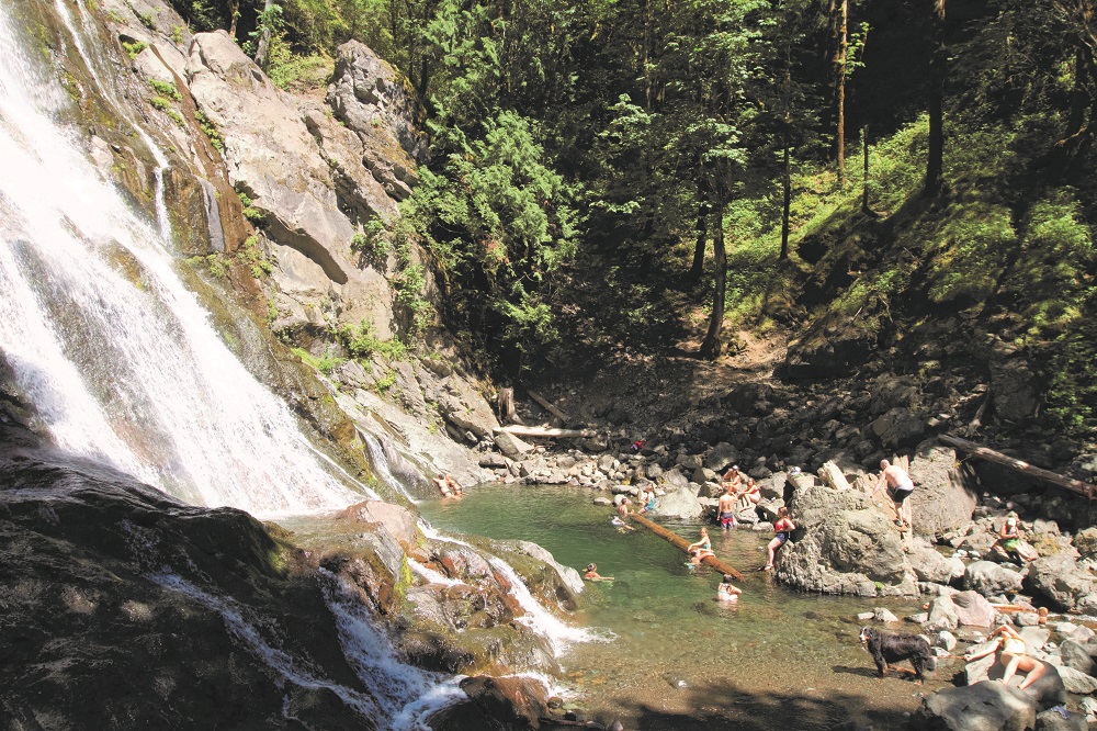
3. Rocky Brook Falls
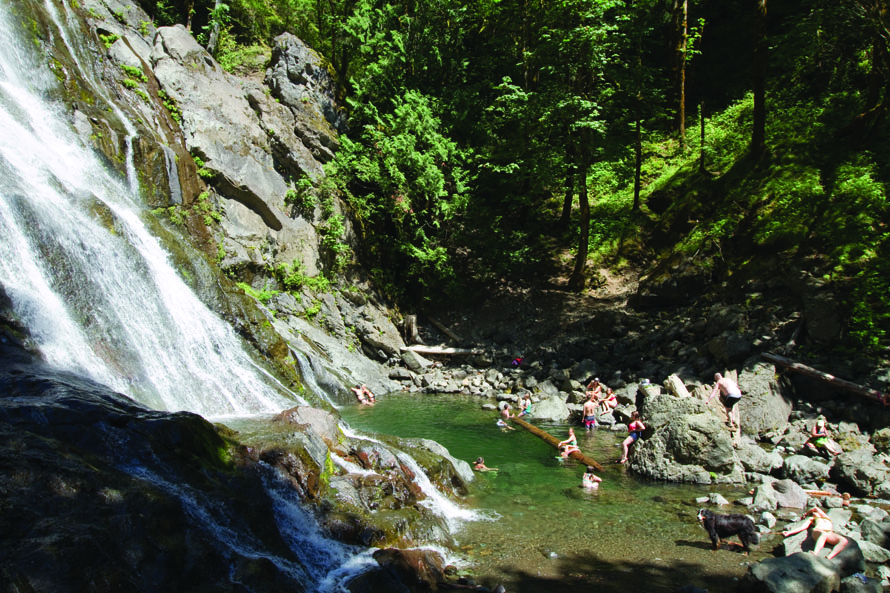
Tour the Olympic Peninsula or hike in Olympic National Park, then stop by Rocky Brook Falls for a swim. It’s off the beaten path just enough to be away from the crowds and your car, but not so far off that it takes all day to get here.
From the roadside parking spot, it’s a pretty short walk along the brook to this waterfall. It’s a pleasant stretch, almost making you wish it was longer when all of a sudden you are there, having gained only 50 feet or so in elevation. You’ll be among other waterfall aficionados, a handful of whom will be there just to see the gorgeous cascading “horsetail-form” waterfall rather than to swim. That said, the area is not huge, and you will be sharing the gravelly beach and larger rocks. If you bring a dog, be respectful of nearby folks and don’t let your pet shake off on top of their picnic blanket (this means you, Huxley el Jefe).
At the base of the waterfall is a pool, with a shallow natural entrance on river right that gets deeper toward the rock face. A couple of rocks jut out far enough to hop off of, though it can’t be called cliff jumping. The pool is deep enough for swimming, but not all that deep, so double-check before taking a leap. A big log might be lazily floating, great for kids to play on as their parents watch from shore. Grown-ups could play on it, too. The water is crystal clear, so bring a snorkel and mask.
Looking up at the waterfall, to the right is a bushwhacked trail that takes you up to a scree field. You might notice a few rock-climbing bolts beside the waterfall, which don’t look overly used, but obviously someone was motivated enough to install them. If you walk up to the top for excellent photo ops, be really careful to (a) not fall off the waterfall and (b) not kick any of the loose rocks down into the pool by accident.
Getting there
From US Highway 101 at Brinnon, 26 miles north of Hoodsport and 11 miles south of Quilcene, turn west onto Dosewallips Road. After 3 miles, park on either shoulder and walk about 0.1 mile along the trail (elevation gain: 50 feet; high point: 200 feet).
Details
- Type: Lowland creek, waterfall, pool
- Location: Walk-in near Olympic National Forest near Brinnon via U.S. 101 on Hood Canal
- Water: Cold, clear, clean, blue-green
- Season: Summer through early fall
- Who’s here: Kid-friendly, dog-friendly; families, retirees, waterfall lovers
- Amenities: Camping nearby
- Local’s tip: Stop by Quil Bean Espresso in the town of Quilcene for a cuppa joe
- GPS coordinates: 47.7189 N, –122.9435 W (parking); 47.7210 N, –122.9416 W (swimming hole)
Next up: Exit 38
4. South Fork Snoqualmie River: Exit 38
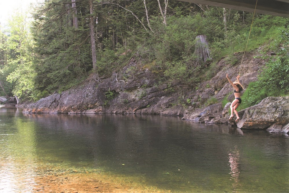
Don’t let the unsexy name of this swimming hole turn you off. Yes, it happens to be just a hop, skip and jump off Interstate 90, and yes, you can hear the cars speeding by in the near distance. But this noise mingles musically with the babbling brook and birdsong, and the proximity to civilization makes this spot ideal for a spontaneous swim. With so many climbing spots, bike routes and hiking trails around, Exit 38 is another swimming hole perfect for a drop-by. When the water level is low and the current is slow, it’s a fine place to bring kids, with a beach near picnic areas — as good as you can get, river-wise.
From the trailhead, it’s a 0.1-mile shady, green walk on Dirty Harry’s Trail. You’ll be far enough away from your car that, for you die-hard urbanites, you’ll feel like you’re getting a break from the city and a little taste of ruggedness, but not so far away that you can’t easily go back to get your left-behind cooler or use the restroom.
After a short jaunt down some rocks (this is the only part that may put older folk and little kids to the test), you arrive at a three-quarters-of-a-circle swath of medium-sand beach. The sun shines brightly here, providing an area to warm up post-swim. Despite its accessibility, the beach is generally very tidy, especially in the early summer. However, later in the season when this turns into more of a picnic spot, it’s likely that signs of human activity will be more evident. In case of beach overpopulation, some river wading will take you to a wide, flat island. The sand here is a little chunkier, but you’ll be surrounded on both sides by the river’s flow.
The water is a lovely clear moss-green, and you can see small fish down below. If you swim perpendicular to the current, you’ll get to a short wall of natural rock across from the beach — it’s more of a shady perch than a jumping-off point. Just north is a bridge, and Instagram tells us that people do occasionally jump off of it, but we aren’t certain about the water being an appropriate depth, so we don’t recommend it (safety first, people, safety first!). Fortunately, if you are jonesing for that splash, on the underside of the bridge are two wee rinky-dink rope swings. A little swing gets you to the deeper part of the river without much to-do. Ponder the graffiti under the bridge, which says, “Takin’ the Plunge.”
Getting there
From I-90 eastbound: From North Bend, take Exit 38 west. Turn right and follow Southeast Homestead Valley Road for about 2 miles, then turn left under the freeway rather than taking the onramp back onto I-90. Park at the Far Side Trailhead in Olallie State Park.
From I-90 westbound: From Snoqualmie Pass, take Exit 38 east. Turn right and park at the Far Side Trailhead in Olallie State Park.
Details
- Type: Lowland-forest river, current, beach
- Location: Short walk in Olallie State Park east of North Bend via I-90
- Water: Cold to cool, clear, clean, blue-green
- Season: Summer into early fall
- Who’s here: Kid-friendly, dog-friendly; bikers, hikers, climbers, teens with colorful t-shirts, families
- Note: Day-use fee or Discover Pass required
- Local’s tip: Climbers, check out the Far Side area, which includes five different crags (Overhaul, Gritstone, Gun Show, Interstate Park, and Winter Block); visit the Mountain Project website for more information. Mountain bikers, check out a long, all-levels downhill ride off Exit 38, given 3.2 hot peppers by a mountain biking website.
- GPS coordinates: 47.4309 W, –121.6322 N
Next up: Leavenworth town beach
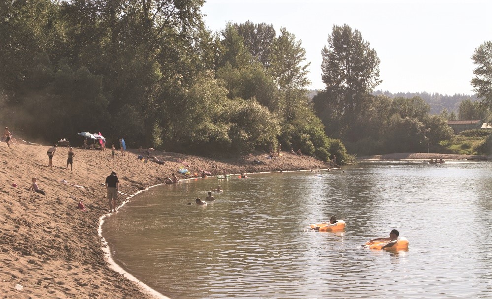
5. Wenatchee River: Leavenworth Town Beach
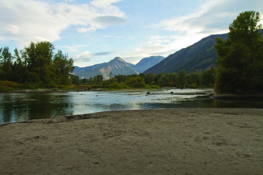
This spot on the Wenatchee River is basically within the town of Leavenworth and truly, no matter where you are within the heart of Leavenworth, you’re only a couple blocks away from the water. The river corridor is protected by the town’s Waterfront Park.
From the park’s big lot right off of Main Street, walk a couple blocks to the river. Though there are a few access points to choose from, this one has a beach that is bigger and broader, and therefore it accommodates the most people. This is where it’s at if you’re looking for a scene. However, if you come after Labor Day, when hints of fall are in the air, it’ll likely be less crowded, occupied by just a few loungers and waders. Whether you’re pro- or anti-crowd, this is the nicest beach on the Wenatchee River.
The park’s main parking lot can also be used to access Waterfront Park’s whole trail system, which interfaces with the town in different areas. Just head south toward the river on Division Street, Commercial Street (west of Eighth), or Enchantment Park Way and you’ll quickly find yourself in Waterfront Park’s trail system. If you are already in town celebrating one of the Bavarian customs, such as brats, beers or lederhosen, the park can be your launching point to explore town.
Getting there
From US Highway 2 in Leavenworth, find Waterfront Park off of Main Street and park in the main lot.
Details
- Type: Lowland river, beach
- Location: Roadside in city park in Leavenworth via U.S. 2
- Water: Cold to cool, clear, clean, blue-green
- Season: Summer into early fall
- Who’s here: Kid-friendly; everyone, tubers
- Amenities: Parking (with portable toilet in season); food and lodging nearby
- Local’s tip: Many upstream tubers exit the river at Leavenworth’s main town beach. There’s at least one company (maybe a couple) that rents inner tubes and provides shuttling so you can tube downriver through town to this point.
- GPS coordinates: 47.5941 N, –120.6565 W