
Take the kids on a history adventure
The day had started out warm and sunny, but just as we’d reached the trailhead clouds had rolled in, and now we found ourselves under a steady rain as we tried to navigate an overgrown path thick with mud. I tried to sound confident for my two grumbling children, but the truth was I wasn’t sure where we were. I was about to suggest to my husband that we turn back when I heard my 11-year-old gasp.
“What?” I asked.
“There,” he said, pointing to an old stone marker just peeking out of a thicket of undergrowth.
“Mom,” he said, “This one is for a little kid.” We had found Franklin Cemetery and a real-life history lesson on the hardships of life in the 1800s.
My family’s first ghost town hike was inspired by my desire for a walk that would feel like an adventure without requiring us to trek too far from home. We’ve been hooked on these hikes that take us out in the wild and back in time ever since.
Ghost town hiking tips
The term “ghost town” generally refers to a town abandoned by its residents, usually after the boom and bust of the local economy. In Western Washington, most ghost towns were once at the center of an active coal mining industry, which boomed during the late 1800s and early 1900s and collapsed almost as quickly with the rise of petroleum, gas and hydroelectric power.
Today, it’s possible to find the remains of some of these towns, but there are a few things to know before you go:
- Although some of the outings described here are more walks than hikes, it’s still a good idea to carry the 10 essentials, and review safety tips info for hiking with kids.
- The ground in these areas is soft, and we have found thick mud on these outings, almost year round, so dress appropriately.
- Be cautious and respectful. All the mine shafts described in this article have been sealed. But still be cautious around old structures and relics. If you’re lucky enough to find a real piece of history, leave it for others to enjoy.
- While the Coal Creek trail and the trails on Cougar Mountain are easy enough for hikers of all ages, the other hikes described are more challenging and will be of most interest to children old enough to appreciate (at least a bit) their historical significance.
First trail: Red Town Trail
Image credit: Sean Munson/Flickr CC
Red Town Trail on Cougar Mountain
It can be hard to believe that the wilderness of Cougar Mountain is in the heart of the bustling Eastside, and that this wild place was once the heart of a booming coal industry, with railways and bustling communities with names like Red Town and Rainbow Town. You can find evidence of coal’s heyday via several easy hikes around the mountain.
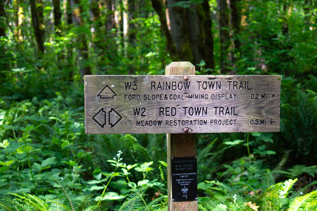
These easy, family-friendly hikes can be accessed at the Red Town trailhead. For your first foray into history, follow the Red Town Trail down to the meadow restoration project (1.5 miles round trip). The field of native plants and blooming flowers was once the field for the Red Town baseball team. You won’t see any relics here, but a bench and a plaque invite you to close your eyes and imagine the crack of a bat and the cheers of the crowd.
Retrace your steps as far as the sign for the Rainbow Town Trail. Walk downhill where you’ll find a sealed mine shaft and old mining equipment. This is all that remains of the once-booming Ford Slope mining operation. A sign offers some pictures and explanations. Imagine the trails around you filled with men with soot-covered faces and the sounds of carts headed hundreds of feet below sea level.
From here, you can take a short walk to the foundations of the hoist. Our boys loved spotting bricks and other remnants in the creek. Head back uphill, or take one of the trails on the right for a less steep route. Children will be able to easily spot coal on the Bagley Seam Trail.
The Coal Creek Trail is across the road from the Red Town trailhead. As you wander the easy trail along the creek, look for remains of what was once a prosperous hotel. You’ll also come to another sealed mine shaft.
Take the short interpretive trail just to the left of it and look for timbers from the old railroad bed in the creek.
The Coal Creek falls are just after, and there are some benches for you to enjoy the view.
Getting there: These trails are easily accessed via I-90 or 405. Arrive early to snag a parking spot.
Pair with: A visit to Triple XXX Rootbeer, a famous diner in Issaquah. It will only take you as far back as the 1950s, but your kids won’t complain.
Next trail: Monte Cristo
Image credit: Terri Stewart/Flickr CC
Monte Cristo mining townsite
Monte Cristo, accessed by a four-mile hike from a trailhead near Route 2, is probably the most famous of Western Washington’s ghost towns. The mining here was for gold and silver. At its peak, thousands of hopeful prospectors staked their claims, and a railroad and other infrastructure was built to haul ore out of the mountains.
As it turned out, the ground was far less rich than geologists had initially thought, and the weather was a constant obstacle. Later efforts to make the area into a resort destination also failed.
Today what’s left of Monte Cristo has been saved, thanks in large part to the efforts of the Monte Cristo Preservation Association.
Trailhead: You reach the Monte Cristo hike from Highway 2, a scenic byway that winds through the Mt. Baker-Snoqualmie National Forest. Park at the lot for Barlow Pass and find the start of the hike just down the road behind an intimidating sign urging caution. It’s eight miles round trip to the town site.
Hike description: Shortly after you leave the parking lot you’ll come to a bulletin board with still more warning signs and a map of the area. A path goes off to the right but stay straight ahead.
Though my family saw evidence of slides on a day we recently hiked the trail, much of this route is an old road, a wide, well-maintained gravel path that hikers of any age can manage. Along the way, you’ll be treated to spectacular views of craggy Cascade peaks towering over the Sauk River. Our boys also loved spotting wildflowers and polliwogs.
The tricky part: At about a mile in, there’s a river crossing — one reason for all those signs, no doubt! If you have young children or the weather is poor, this should be your turnaround point.
If you have sure-footed hikers and good weather, you can cross the river downstream on a makeshift log bridge. To reach it take the trail to the right up to the wooden sign for “Weeden Creek.” Go behind this sign and make your way down to the river, where a wide log will be your crossing. We first did this hike on a late summer day when the log was dry, and the water was low, and we didn’t find it intimidating at all.
On our spring visit, it was slick from rain, and the river was high and fast moving. There was no way we were going to chance it. Luckily, my boys were fine with a wilderness walk.
To check on current conditions, call the Verlot Ranger Station. You can also check the Washington Trails Association site for recent trip reports.
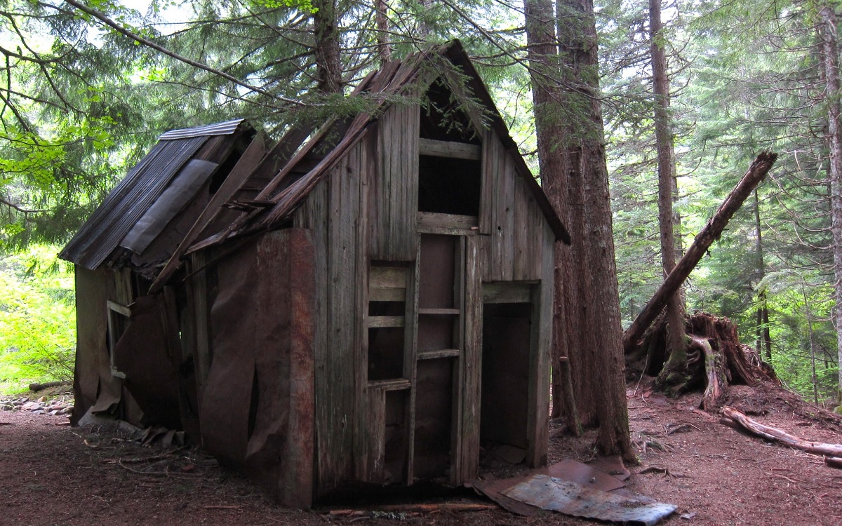
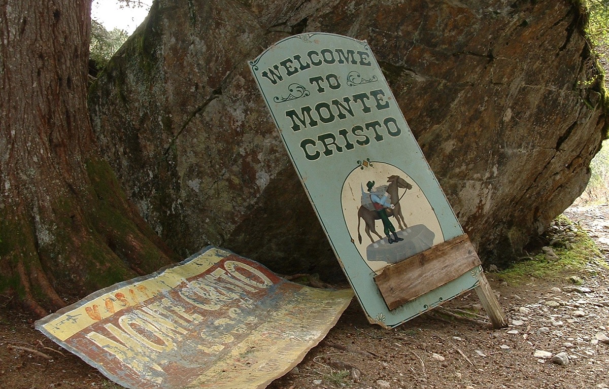
The Monte Cristo town site: If you’re able to continue, the town site is about three miles after the river. You’ll stay on the path, crossing the river again on a high bridge (this time a wooden one in good condition) just before the entrance to the town. An old welcome sign greets you and you’ll find old buildings, mostly boarded up, as well as rusted signs and equipment. Sit a while and imagine the scene alive with people seeking their fortunes!
Note: Be sure not to disturb any of the buildings, signs or tools you may find. Also, be aware that there are still some privately held mining claims and cabins near the town site. Don’t go on areas marked as private property.
Amenities: There are several picnic benches, though pack in your own water due to the presence of arsenic and other heavy metal contamination. We also found the bathrooms unusable, so take advantage of the one at the Barlow Pass trailhead.
Getting to the Monte Cristo trailhead: Head towards Granite Falls from Seattle. Take the Mountain Loop Highway East to Barlow Pass. You’ll need a Northwest Forest Pass to park for this popular trail, which can have some snow on the ground into late spring.
Pair with: This hike is in the heart of the Mt. Baker-Snoqualmie National Forest, where you’ll find many other hikes, picnic areas and campgrounds if you want to extend your adventure. If you’re ready to head back to civilization, Granite Falls has kid-friendly restaurants. Playa Bonita is a popular choice with local families.
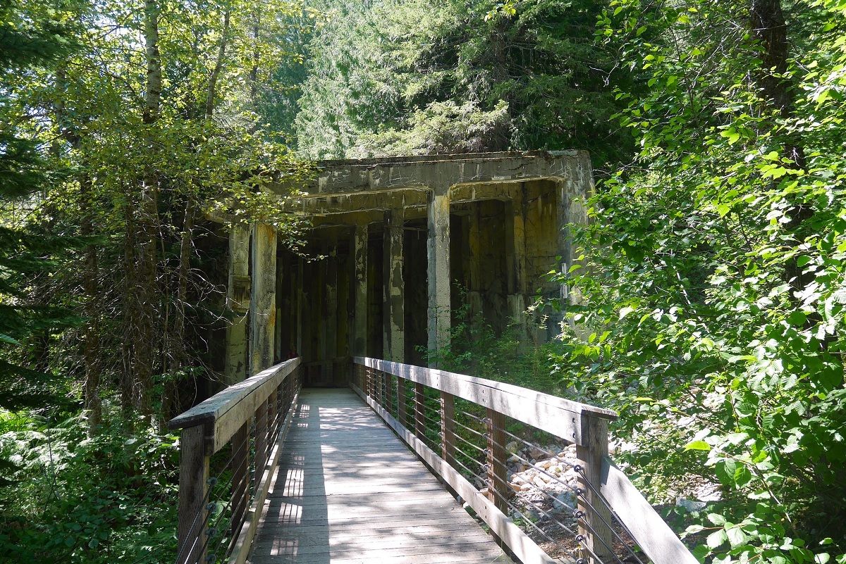
Next trail: Franklin townsite
Image credit: GraceMarcellaNorman/Flickr CC
Franklin townsite
Begin your trip to the former coal boom town of Franklin with a stop at the museum in Black Diamond, about 45 minutes from Seattle. Though small, the museum is packed with relics of the area, including pictures of the men and women who walked on the long-abandoned paths you’ll be exploring. My children were fascinated by the old mining tools. Be sure to check the displays outside, which include a restored locomotive with a bell to clang and a horn to sound. Admission here is free, though donations are welcome.
Franklin town site: After you’ve primed the troops for your adventure, head just a few miles out of town on Lawson Street, which turns into Green River Gorge. The entrance to the town site is right before the bridge across the gorge, marked by a chain link fence. Find parking at the cemetery and walk back approximately a quarter of a mile, being careful of traffic on this curvy, two-lane road. The fence looks intimidating, but Washington State Parks now owns the Franklin historical area, and there is an easement allowing you to use the short, gravel section between the chain link fence and the yellow gate with state parks signage that marks the start of your hike.
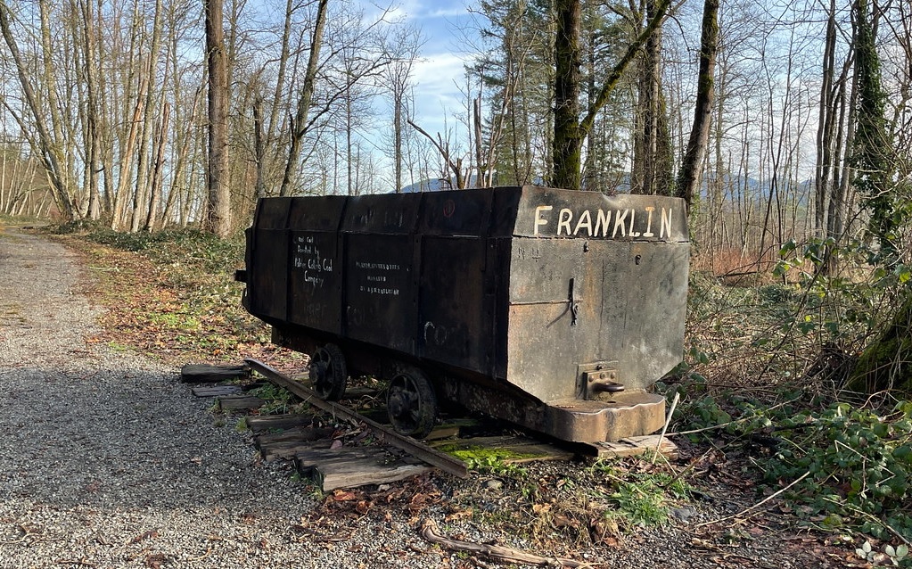
The hike: From here, you’ll head up a wide, gravel road. At the top of the hill you’ll see an old coal cart and signs. There are a few pieces of old foundation just down the road to the right, which leads into what was once the main part of the town. This is Palmer Coking Company property, but they are happy to issue you a permit at their offices. Note that they’re only open on the weekdays, so plan ahead if you’d like to do this.
Mineshaft and cemetery: Alternatively, stay on state parks land by heading left at the coal cart and following the sign that points toward the cemetery. You’ll first come to a sealed and gated mine shaft. My children were wowed by its depth and enjoyed dropping rocks through the grating.
Just behind you is a narrow path that will lead to the cemetery. It’s a pretty, wooded trail, though it is overgrown in some sections and muddy in others. Eventually, you’ll see the remains of an old wooden trestle on the right. Shortly after that, you’ll see the first stone grave markers honoring former residents who died more than 100 years ago. Look for a short path to the right to find a small, fenced section around more tombstones, along with signage.
If you’d like a longer adventure or more of a true hike, pick up a permit and scramble up some of the hills on Palmer Coking Company land for impressive views of the Green River Gorge.
Getting there: The museum is in Black Diamond, approximately 45 minutes from Seattle. Take I-5 to 405 towards Renton. At Exit 4 take WA 169 towards Maple Valley/Enumclaw and continue following 169. The museum also hosts guided tours a couple of times during the year, if this outing sounds too ambitious for a do-it-yourself adventure.
This hike is also well described in “Hiking Through History Washington” by Nathan Barnes and Jeremy Barnes.
Pair with: Finish your hike with a stop at the Black Diamond Bakery. It’s just down the street from the museum. Try the pie!
Next trails: More history hikes
Image credit: Shutterbug Fotos/Flickr CC
More history hikes near Seattle
Lime Kiln Trail: Lots of old tools and a former lime kiln that will impress kids. Described in “Day Hiking North Cascades” by Craig Romano.
Iron Goat Trail: Follow an old railroad bed and peer into dark tunnels.
Fairfax and Melmont:Two ghost towns near Carbonado in Pierce County. Editor’s note: Access via Mowich Lake Road is closed for the 2023 season.
The Underground Tour in Seattle is a stroll and a tourist attraction, but kids who enjoy these hikes will love it.
Resources
Historylink.org: A free, online resource on Washington State History with excellent background on the history of coal mining and other early industry in the Puget Sound region.
MOHAI in Seattle and the Washington State History Museum in Tacoma both have artifacts and history exhibits.
Ghost Towns of Washington: Extensive lists, but no directions.
The sibling duo behind the excellent site Hiking With My Brother has a guide called “Hiking Through History.” Only a few of the hikes are true ghost towns, but it’s a worthwhile addition to your guidebook shelf, with historical background on many popular hikes as well as some you may not have discovered.
Washington Trails Association: Lengthy descriptions of several of the outings described in this article, plus many hike suggestions and recent trip reports.
More great family hikes
Editor’s notes: Image credit this page: Tony Credit/Flickr CC. This article was originally published several years ago and updated most recently for 2023.