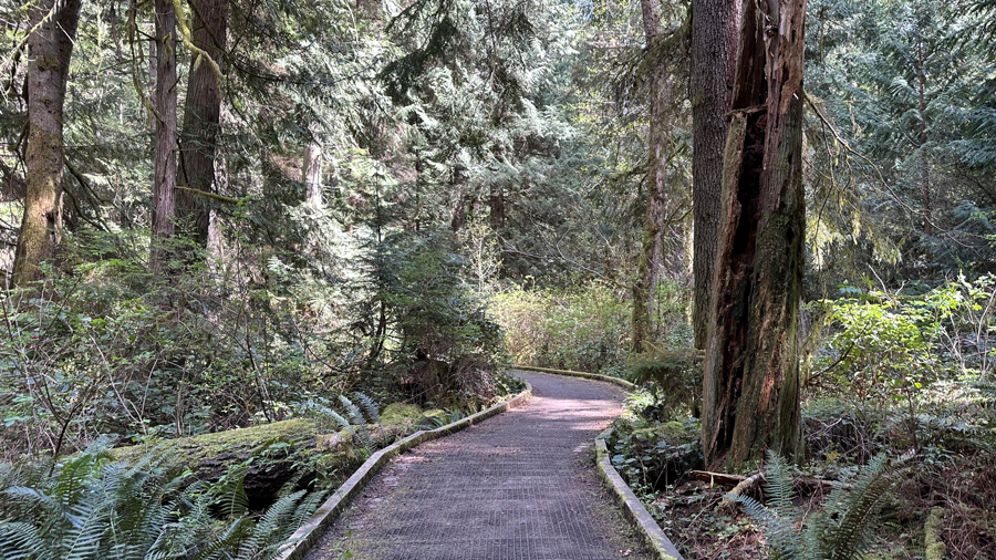
If you want to get your crew away from screens and out in nature, these scenic hikes are for you. From in-city hikes in gardens and parks to the trails of Mount Rainier, these cool hikes all offer accessible distances for kids, plus each one has one or more fun footbridges to add interest. You can walk across suspension bridges, bridges made out of fallen trees, stone footbridges over a creek and even boardwalks traversing wetlands. Take in views of the water and keep an eye out for wildlife!
To make it easy to plan, I’ve organized these bridge hikes by driving distance from Seattle.
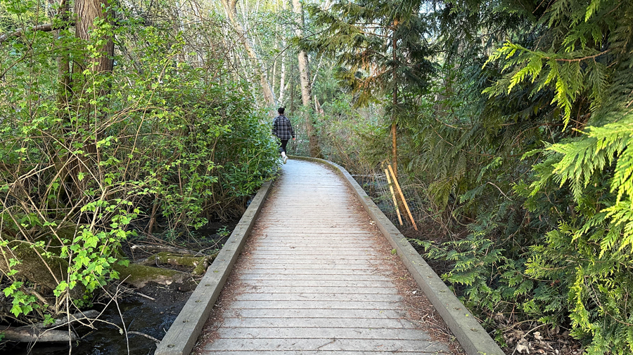
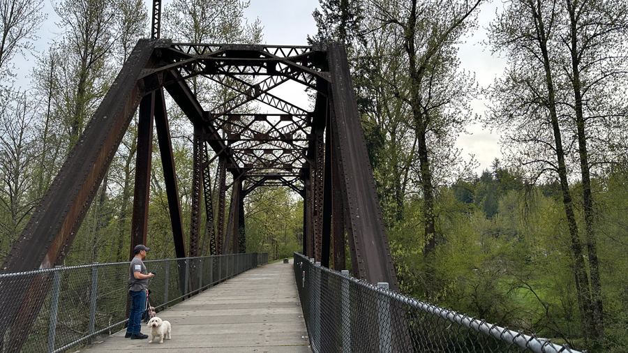
Carkeek Park, Seattle
Location: 950 N.W. Carkeek Park Rd., Seattle
Trails: Piper’s Creek, Wetlands Trail
Hiking distance: 4.2 miles (Piper’s Creek and Wetlands Trail Loop); 1 mile out-and-back to the beach and wetlands
Park near the playground of this gorgeous park and you’ll be able to spot the bridge to the beach from the picnic area, building excitement for kids before the hike begins. Take the Piper’s Creek Trail toward the bridge, about a third of a mile away. The bridge goes up and over train tracks, and if you are lucky, you can see (and feel) a train passing underneath as you cross. The bridge over the tracks is enclosed in chain-link fencing, making it feel very safe for kids.
After crossing, descend to the sand via a staircase. The beach offers sand, driftwood to sit on and amazing views of the Olympics. After you’ve enjoyed the beach, cross back over and turn right to follow the Wetlands Trail. This is a boardwalk over wetlands that is partially closed due to damage, but you can walk far enough to see beaver dams and gnawed-on trees. You might even catch a glimpse of the resident rodents swimming around. We were lucky to see beavers swimming and even emerging from the water to nibble on grass.
After viewing the wetlands, you can head back to where you started for a picnic, let the kids play on the swings or the salmon slide, or explore more trails at the park.
Parking: There are multiple free parking areas. Park at 1514 N.W. Carkeek Park Rd. to be close to the picnic tables, grassy play area, salmon slide playground and restrooms.
Restrooms: Full restrooms at the main western lot next to the playground
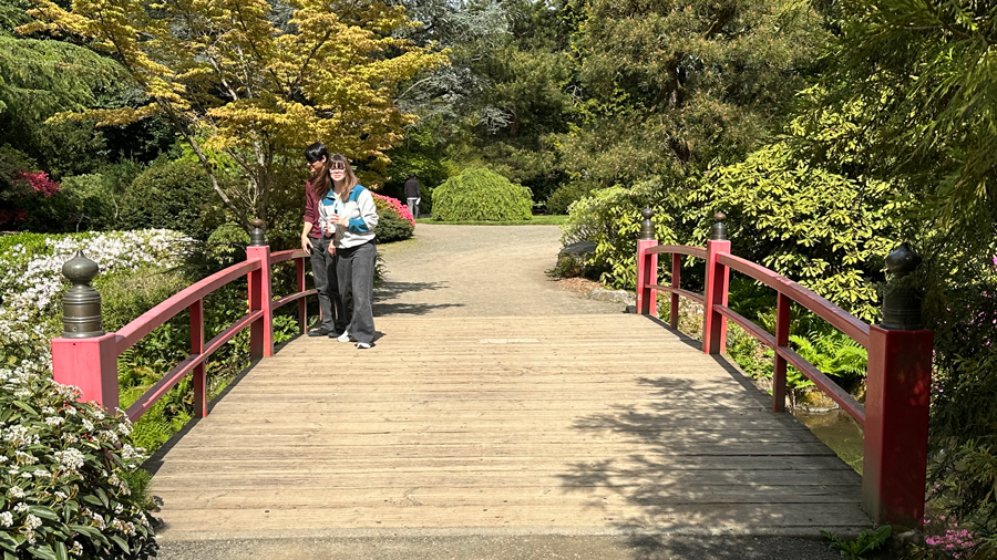
Kubota Garden, Seattle
Location: 9817 55th Ave. S., Seattle
Hiking distance: 2 miles
A 20-acre Japanese garden, Kubota Garden, is open daily and free of charge (donations welcome). It is a beautiful and relaxing park with waterfalls, stone lanterns, footbridges, a koi pond, and, of course, beautiful trees and flowers. Just outside the gate, pick up a map with a self-guided tour from the kiosk, or download one in advance.
Once you enter, you will see a large hanging bell across from the drinking fountain. It is traditional to ring the bell by knocking on it with your knuckles to let the spirits know you are there. (Kids love this.)
The trails aren’t named, but you can follow the paths to the numbered highlights listed on the map. Let the kids choose their own adventure! We walked about a mile and saw most of it. Most paths are gravel and would be accessible for strollers, but there are also small offshoot trails made of dirt, and some have stone steps.
There are two main footbridges. The Heart Bridge features red railings and crosses over Mapes Creek. The Moon Bridge also has bright red railings and is built in a hill shape, as a symbol of living a good life: “hard to walk up and hard to walk down.”
Be sure to check out the spring-fed pond to spot turtles and koi fish, and as you stroll, there are many smaller stone bridges crossing other water features. This is a place that is fun to wander and discover new things to see around every corner.
Parking: Free lot near the entrance; street parking may be limited due to construction. Note that Seattle Parks and Recreation recommends removing all valuables from your car.
Restrooms: Open 7:30 a.m.–3 p.m., Monday–Saturday. A portable toilet is also available near the restroom building.
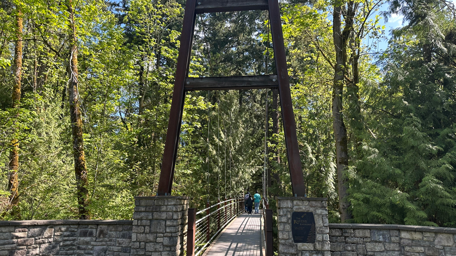
Bellevue Botanical Garden
Location: 12001 Main St., Bellevue
Trails: Tateuchi Trail, Ravine Experience, Bird Loop
Hiking distance: 0.75 miles
A gem right in the middle of the city, Bellevue Botanical Garden features a wide variety of Pacific Northwest plant life divided into smaller, themed gardens and a fun suspension bridge over a ravine. You can pick up a map at the entrance (or download one in advance), along with a scavenger hunt game for kids.
There are several footbridges over wetland areas, but the star is the Ravine Experience, a 150-foot suspension bridge built over a ravine. From the entrance, follow the Tateuchi Trail toward the Ravine Experience. As you walk, the gardens gradually give way to the forest. The suspension bridge is about one-third of a mile from the entrance. You will pass a lovely waterfall and many pretty blooms along the way.
Take your time on the bridge as there is a lot to see below it, from a babbling brook to the forest floor. After exiting the bridge, the Bird Loop trail (a quarter-mile) offers informational signs about native birds, plus I heard lots of birdsong on my visit.
You can wander as much or as little as you like here, and there are benches for resting along the way. The paths vary from paved to gravel or mulch, but an all-terrain stroller could handle the paths, including the bridge. There is a coffee cart and gift shop as well, which are open seasonally.
Parking: Free parking lot
Restrooms: At the entrance
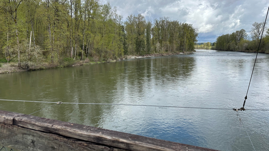
Tolt-MacDonald Park, Carnation
Location: 31020 N.E. 40th St., Carnation
Trail: Cottonwood Loop
Hiking distance: 2.4 miles
This gorgeous park in Carnation offers hiking trails and a suspension bridge. The Cottonwood Loop trail is a 2.4-mile trail with 160 feet of elevation, beginning and ending with the bridge. The scenic trail winds through a forest with lots of pretty moss and colorful shelf fungi and, of course, cottonwood trees. The surface varies from a wide gravel path to a narrow dirt trail and even a section with sand. In the fall, you can see salmon in the river. The gentle, shaded trail is kid-friendly but not stroller-friendly. There are reports of bear sightings in the past, and it is recommended that hikers carry bear spray. (I didn’t see any large wildlife on my hike in mid-April.)
The park’s entrance is located at Northeast 40th Street and Highway 203. From the parking lot, walk past the gate and take the dirt footpath to the left of the street. Soon, you will cross over another small parking lot and see a sign for the John MacDonald Memorial Campground, with the huge bridge just beyond it. This 500-foot suspension bridge connects the east and west sides of the park across the Snoqualmie River. The bridge is wide with tall rails, good for looking down at the river below. You can definitely feel it moving. If that bothers anyone in your hiking party, they can cross while holding one of the handrails. Once you exit the bridge, follow the trail straight ahead until you come to a Y intersection with a sign: ”Small Group Camp, Boy Scout Amphitheater.” Go right to follow the Cottonwood Loop trail. The trail is well marked and loops back to the suspension bridge. There is one short, steep downhill section, but the rest of the trail is a gentle up-and-down hike.
Parking: Free lot
Restroom: Portable toilet in the parking lot
Henry’s Ridge Open Space, Maple Valley
Location: 253rd Place Southeast, Maple Valley
Directions: From Maple Valley Highway 169, head east on Southeast Maple Ridge Drive, then turn right on 253rd Place Southeast.
Trails: Stinger, Once Upon a Time and Derailer
Hiking distance: 2.5 miles
This network of trails in Maple Valley — which is popular with mountain bikers — features three footbridges, old-growth forest, hanging moss and trails named after fairy tales. This area gets dark really quickly, so allow plenty of time before sunset for your hike, and download a map in advance, just in case you lose cell service.
Enter at the trailhead called The Boulders. Go down the gravel path and turn right onto Stinger, which begins with a bridge. After about 0.3 miles, you will come to a Y intersection, take the path to the right. When you reach a gravel road, cross over and on the opposite side, you will see the trail sign for Once Upon a Time. Enter Once Upon a Time and keep going until you get to Derailer, designated by a square, white sign with a black diamond in the center, high up on a tree on the right. On Derailer are two bridges, both made of logs. One is wider and has wooden slats nailed onto a large fallen tree trunk. Adventure seekers can traverse the narrower bridge, a log covered in chicken wire.
Reverse the directions to head back the same way you came. One note: when you are on Derailer and get to the intersection for Once Upon a Time, from this direction, there is only a small sign on a tree with OUAT (instead of the trail name spelled out) on it.
For a fun side quest after your hike, check out the Maple Valley Gnome Trail a couple of miles away.
Parking: Street parking; no pass needed. Park on the street on the right curb as you go down the hill past Southeast 279th Place. The trailhead will be across the street to your left. (Pay attention to signage and don’t park in front of driveways or between the “no parking” signs.)
Restrooms: None on the trail; nearby Four Corners shopping area has a Safeway and Fred Meyer if anyone needs a restroom before or after the hike.
Cedar River Trail, Maple Valley
Location: Highway 169, Maple Valley
Hiking distance: 1 mile out-and-back to cross the footbridge; the entire trail is 17.4 miles
This trail follows the Cedar River from Maple Valley to Renton for a total of almost 18 miles. The route I am highlighting here is in Maple Valley and is both stroller- and dog-friendly.
From Highway 169, there is a medium-sized parking lot right next to the trail, across the highway from Light Dental Studios. Once you park, if you are facing the trail, there is a dirt trail from the lot down to the paved path. Turn right and start down the wide, paved path. You will go under the overpass and through a short tunnel (great for echoes!) before getting to an old metal bridge over the river. This is a beautiful view and during salmon season, a great spot for spotting fish. If you keep going, you will pass over another footbridge over a street. You can turn around here for about a 1-mile walk.
Fun side quests: At the south end of the bridge, there is a short trail going down to the river; this path is dirt and steps, so not for strollers. There is a great pizza place called Cascadia Pizza nearby, which you can access from the trail (or you can drive there).
Parking: Free parking lot at the trailhead
Restrooms: None
Forest to Sky Trail, Bainbridge Island
Location: 11299 Arrow Point Dr. N.E., Bainbridge Island
Hiking distance: 1.8 miles out-and-back
This short trail connects Battle Point Park and Grand Forest West Nature Preserve. You can do this as an out-and-back hike by beginning and ending at Battle Point Park, which is an amazing place to play. The biggest problem you will have is tearing the kids away from the park to hike!
The trail begins at the back of the parking lot near the tennis courts. Walk along a path that goes by the Pea Patch Community Garden, keeping the fence on your left. After about 0.4 miles, you will come to the trailhead, which is clearly marked. This pretty trail winds through the forest, crossing over a short bridge that goes over a creek, and a longer boardwalk that takes you over wetlands.
We saw lots of trillium (reminder: these are illegal to pick or disturb), salmonberry bushes and ferns. This is a very peaceful walk with lots to look at and lovely birdsong. If your hikers want additional adventure, at the end of the trail, you can cross the street and check out the trail network in Grand Forest West.
Parking: Ample free parking at the park
Restrooms: Portable toilets and regular bathrooms near the play structure
Skyline Trail to Myrtle Falls, Mount Rainier National Park
Location: 52415 Paradise Rd. E., Ashford
Hiking distance: 1 mile
This short trail is accessed from the north side of the visitor center’s upper parking lot at Paradise. Myrtle Falls, a 72-foot horsetail waterfall, is one of the most photographed spots at Mount Rainier. The path is paved and leads to a footbridge with a view of the falls and the mountain.
The trail is well signed and very popular, so you can probably follow the crowd! It is about a half mile to the falls, making the hike about a mile round-trip. There is an offshoot trail to a lower viewpoint that is steeper and not stroller-friendly, so use caution if you take that trail. This is a summer hike — the trails are often snow-covered in winter. Check conditions and closures before you go. And good news for spontaneous families: Mount Rainier no longer requires timed-entry reservations.
Parking: Park in the upper lot at the visitor center. An entrance pass is required: $30 day pass or $55 annual pass.
Restrooms: Located at the visitor center
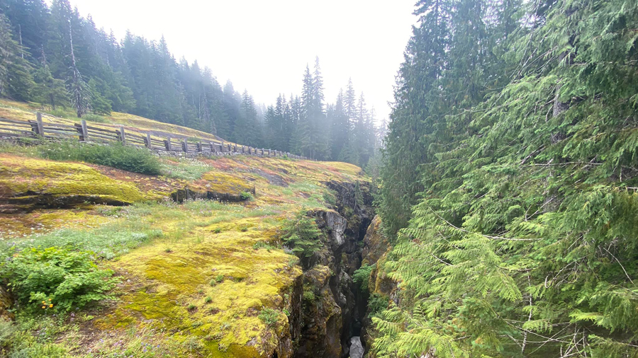
Box Canyon, Mount Rainier
Location: Stevens Canyon Road, Packwood
Directions: From the Paradise Road wye, Box Canyon is 8.7 miles east along Stevens Canyon Road, or 10.3 miles if heading west from the Stevens Canyon Entrance.
Trail: Box Canyon Loop Trail
Hiking distance: 0.5 miles
Box Canyon Loop Trail offers dramatic views of a slot canyon carved by the Muddy Fork of the Cowlitz River. This trail is located along Stevens Canyon Road, which is open seasonally, usually from around Memorial Day to fall. Check conditions and closures ahead of your visit.
From the parking lot, you will need to cross the highway to get to the trailhead. This trail is a half-mile and follows the canyon along one side, then crosses a footbridge before heading back along the other side. Visitors come for the views of the river crashing through the canyon, which are said to be amazing. There are some steps on the trail. At the parking lot, there is also an overlook with interpretive signs about the geology of the area.
Parking: There is a parking area off of Stevens Canyon Road. An entrance pass is required: $30 day pass or $55 annual pass.
Restrooms: There is a vault toilet typically open seasonally, but no potable water or flush toilets for 2026.